 |
Introduction
Runoff from
construction sites can contribute significant sediment loads to
receiving water. Thus, effective erosion and sediment control at
construction sites are crucial in stormwater management. This module
focuses on the development of erosion and sediment control plans
at construction sites. Good planning is the first step in preventing
sediments from damaging the receiving water ecosystem. However,
it is equally important to ensure erosion and sediment control measures
are correctly installed and maintained on site.
Water
Erosion
Water-induced
soil erosion is caused primarily by falling raindrops which dissipate
their energy and the shearing force of surface runoff. The whole
process involves detachment of soil materials, transport of soil
materials, and deposition of eroded materials.
There are four
main erosion types as indicated in the following diagram.
- Raindrop
erosion is caused by the direct impact of falling rain drops on
soil particles. This impact dislodges soil particles and splashes
them into the air. The dislodged soil particles can then be easily
transported by the flow of surface runoff.
- Sheet erosion
is referred to the removal of a layer of exposed surface soil
by the action of raindrop splash and runoff. The water moves in
broad sheets over the land and is not confined in small depressions.
- Rill and
gully erosion is caused by concentrated runoff in rivulets, cutting
several inches deep into the soil surface. These grooves are called
rills. Gullies may developed in unrepaired rills or in other areas
where a concentrated flow of water moves over the soil.
- Stream and
channel erosion is caused by increases in the volume and velocity
of runoff

The principles
of ESC are prevention of erosion and control of sediments from leaving
the construction site. Erosion prevention should be the primary
objective of ESC planning. However, conventional approach in ESC
planning is still focused primarily on sediment control unless regulatory
agencies enact strict regulation on erosion prevention.
The typical
steps of ESC planning are identification of problems areas, selection
of erosion and sediment control measures, and preparation of document
and drawings.
The following
pictures show the typical problem areas at construction sites where
erosion and sediment are likely to occur.
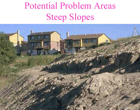
- Unprotected
steep slopes are prone to erosion as runoff velocity is high.
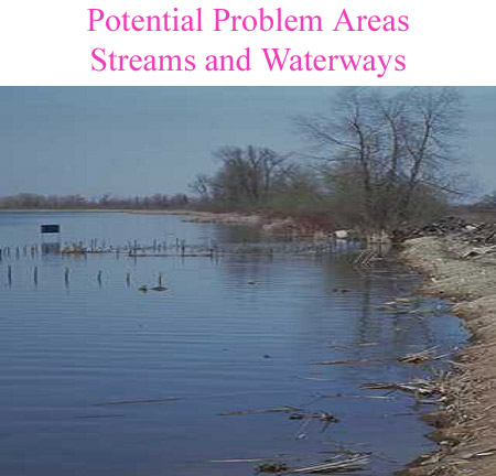
- Any construction
works near or at streams or waterways are caused dislodged sediments
to enter water directly.
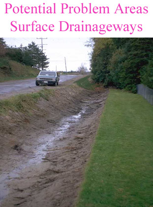
- Unprotected
drainageways such as ditches are a source of sediments as runoff
concentrates and moves quickly.
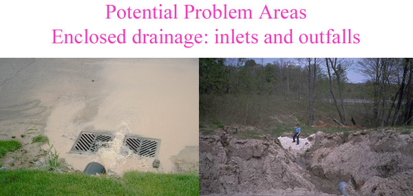
- Storm inlets
should be protected from sediment laden runoff which may clog
underground storm sewers. High discharge velocity at a storm outfall
may cause significant erosion downstream.
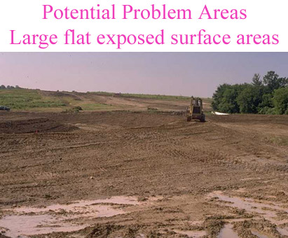
- Large flat
exposed areas are prone to sheet erosion and should be protected.
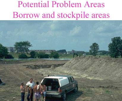
- Borrow and
stockpile locations are exposed areas which are disturbed continuously
over the construction period.
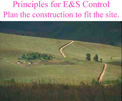
- Plan
the development to fit the site characteristics.
Site characteristics such as topography, soils, drainage patterns,
and covers should be considered when developing a site. Areas
which are prone to erosion should be left undisturbed and undeveloped
if possible. Entrance and exits points for runoff should be protected
from erosion and equipped with sediment control devices.
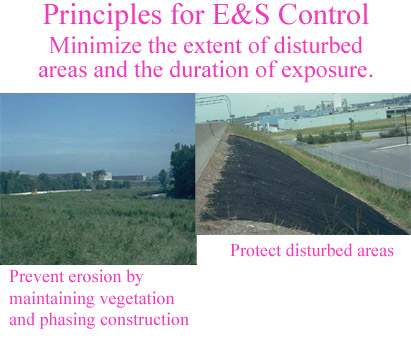
- Minimize
the extent of the disturbed area and the duration of exposure
and stabilize disturbed areas as soon as possible
Conventional land development practices favour grading of the
whole site in the beginning of the project. Sometimes, a development
may take years to complete. Thus, we have these disturbed areas
which may last a long time and subject to erosion. The key of
ESC is to minimize the extent of disturbed areas by phasing. Grading
of development sites should be consistent with the development
plan. By staging construction and preserving existing vegetation,
erosion can be reduced significantly. Once a land surface is disturbed,
we should minimize the duration of exposure by protecting it from
erosion if possible. Typically, if an area is not going be worked
on in more than 45 days, it should be protected by erosion control
mats. The State of Maryland has demonstrated the effectiveness
of stage construction by enacting strict regulation on grading
practices.
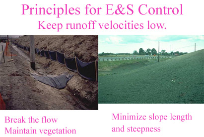
- Keep runoff velocity low.
Runoff velocity should be kept as low as possible. For drainageways
such as ditches, high velocity can be reduced by a series of rock
check dams which break the flow velocity. Overland flow velocity
can be reduced by minimizing slope length and steepness.
- Direct
runoff away from problems areas
Concentrated flows if possible should be diverted away from problems
areas as discussed in the last section.
- Retain
sediments within the site area.
Sediment control devices such as sediment control ponds should
be used to retain sediments from leaving the site.
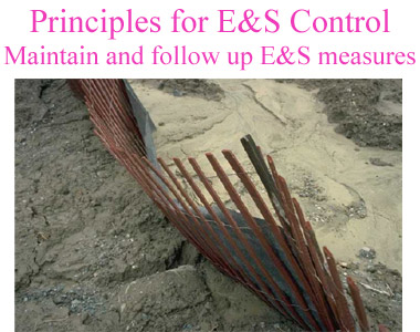
- Implement
a thorough maintenance and follow-up program.
Poorly maintained ESC devices are not going to work effectively.
Budgets should be allocated for inspection and maintenance of
ESC devices over the construction period.
- Planning
should be focused on pre-grading, after grading, during construction,
and after construction phases. Different techniques may be required
for each phase of development.
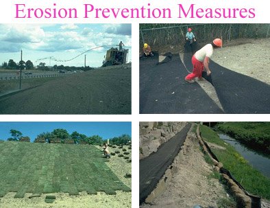
Erosion control
devices include:
- Temporary
seeding
- Temporary
mulching
- Permanent
sodding
- Temporary
or permanent erosion control blankets
- Permanent
vegetative buffer strips
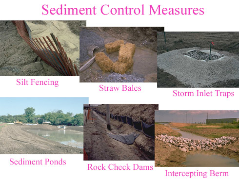
Sediment control
devices include:
- Site fencing
- Straw bales
- Sediment
basins
- Sediment
traps
- Storm inlet
traps
- Rock check
dams
- Interception
berms/swales
An ESC plan
is:
- A written
descriptive portion and a visual component of maps and plans
- Detailed
depend upon the construction site and the surrounding streams
and lands
- It is often
integrated with stormwater management or drainage reports
- Location
maps and property lines
- Limits of
disturbance
- Existing
site information
- Proposed
grading
- Control
measure details
- Construction
schedule
- Stabilization
details
The reasons
for a failed ESC plan may be:
- The E&S
plan did not address all stages of construction
- Changes
occurred on adjacent sites
- On-site
changes were made
- Devices
were improperly installed
- Maintenance
activities were not conducted
- Excessive
rainfall occurred
An Example
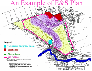
Problem areas:
- The steep
slopes in the southern portion of the site
- The watercourse
along the south-west and southern portion of the site
- The railway
ditch along the east side of the development
Principles:
- The development
is a 17 lots rural subdivision. It is designed to maximize the
development areas and may not fit the site characteristics. This
is typical in most situations as designers and planners rarely
pay attention to ESC in the draft plan.
- The railway
ditch along the east boundary should be protected from excessive
runoff which may cause erosion
- Stockpile
areas should be located as far as possible from the watercourse
- Construction
of houses should start from the lots farther away from the watercourse
- Sediment
control devices should be located at the low point of the development
(i.e. near Lot 5 and 7)
- Sediments
from overland flow should be controlled around the perimeter of
the site
ESC Devices:
- Silt fences
along the perimeter of the site
- A sediment
control pond at Lot 7
- Rock check
dams along the railway ditch in the east
- The stockpile
area is located in Lot 18 and 19 at the north-east corner of the
site
|