 |
Introduction
As we discuss
about stormwater management, we have to bring up the topic of hydrology.
This topic is studied by various disciplines. This module attempts
to present the basis of engineering hydrology. It starts with the
concepts of engineering hydrology and water balance and follows
by rainfall-runoff processes, and hydrologic routing. Readers who
are interested to learning about groundwater hydrology may want
to do further readings in hydrogeology.
Engineering
Hydrology
Hydrology encompasses
the occurrence, distribution, movement, and properties of the waters
of the earth. It involves the interaction of water with the physical
and biological environment.
Hydrologic
system is a system of interrelated components, including the processes
of precipitation, evaporation, transpiration, infiltration, groundwater
flow, streamflow, etc., in addition to those structures and devices
that are used to manage the system. Hydrologic system is subject
to different kind of weather pattern and spatial complexity, and
is dynamic and random in nature.
Hydrologic
evaluations are required to determine the characteristics of the
hydrologic system including the evaluation of the magnitude of various
events and the frequency of certain magnitudes.
Engineering
hydrology is a Apractising art@ concerned with the analysis of hydrologic
systems and hydrologic evaluations related to planning and design
objectives. One of the major problems in engineering hydrology is
the lack of measurement at the location of interest.
Approaches to
Engineering Hydrology:
- Statistical
analysis of historic records
Based on the analysis of past records of the system, the future
behaviour of the system is estimated statistically. This approach
assumes that land use, climate, vegetation, soil conditions, and
other factors must all be static.
- Extension
of records
For short records, theoretical models which are based on physical
or statistical laws can be used to extend the existing data record.
- Transferring
of records
If records are short or inadequate at a location of interest,
previous records from a similar catchment may be used to predict
the system behaviour. It is important that the system performance
be related to a set of easily-measured characteristics.
- Hydrological
Modelling
If records are short or inadequate at a location of interest,
a mathematical model is used to simulate the hydrologic processes
directly. The mathematical model transforms the inputs such as
rainfall to output such as runoff or streamflow. This transformation
may involve simple conceptual models to complex physically based
models.
Hydrologist
usually define regions of analysis using the concept of watershed.
A watershed is the land area that contributes surface runoff to
any point of interest. The hydrologic system components interact
with each other and the processes involved are enormous and complex.
Nevertheless, important watershed processes should be identified
so that the hydrologic system can be analyzed adequately. Inputs
to the hydrologic system are rainfall and/or a regional groundwater
flow system while outputs are groundwater outflow from the region,
receiving channel and stream flows, and evapotranspiration to the
atmosphere. Hydrologic processes are a function of the characteristics
of the study area such as climate, topography, geology, soil cover,
vegetation, land use and human activity. Although watershed processes
are complex, it may be represented in a simplified way. For instance,
evapotranspiration is usually assumed negligible when floods are
being simulated but must be included in studies of long-term reservoir
operation.
If we can identify
all the important inputs and outputs of a hydrologic system, a water
budget analysis can be conducted which would give an estimate of
the magnitude of hydrologic components. Hydrologic budget is usually
applied to a well defined region. Watersheds are the easiest to
deal with since they sharply define surface water boundaries.
In order to
apply the hydrologic budget equation, we need to define a control
volume or a region which is fixed in space and completely surrounded
by a control surface through which matter can freely pass. By identifying
all inputs and outputs through the control surface, a change of
water inside the control volume can be computed using the following
conservation equations:

where I is
the amount entering the region in a specified time period delta
t, Q is the amount leaving, and delta S is the amount of change
within the system.

where i and
q are the instantaneous input and output rates.
Although the
concept of hydrologic budget is simple, the identification and quantification
of inputs and outputs may be very complex.
Hydrologic
budget equations can be developed for the surface system, subsurface
system, and the combined system. The difficulty in solving these
equations for practical problems lies mainly in the inability to
measure or estimate properly the various hydrologic equation terms.
Precipitation is measured by rain or snow gauges. Surface flows
can be measured by weirs, flumes, velocity meters and depth gauges.
Soil moisture can be measured using neutron probes and gravimetric
methods. Infiltration can be determined locally by infiltrometers.
The extent and rate of movement of groundwater are usually exceedingly
difficult to determine and adequate data on quantities of groundwater
are not always available. The determination of quantities of water
evaporated and transpired is also extremely difficult.
One of the
fundamental tools used in defining hydrologic response has been
a water balance analysis. This type of analysis has historically
been used to obtain an understanding of the overall hydrologic response
of an area or watershed. While not generally being overly detailed,
the analysis gives a basic understanding of the rainfall-runoff
relationship over a long term planning period (e.g., seasonal or
yearly). The outcome of such an analysis allows for the general
breakdown of the components and their percentages which go into
defining runoff from a site, surface and subsurface.
A typical water balance analysis will compare meteorological input
data to a measured (or transferred) set of flow data within the
receiving stream. The analysis of the streamflow over time allows
for this data to be broken down into surface runoff and ground water
or baseflow components. The flow data along with typical estimates
of evapotranspiration losses and the input meteorological information
allows for breakdown of each component and a determination of infiltration,
baseflow and the surface flow components of individual site water
balance.
A water balance (or hydrologic budget) analysis gives information
which can be useful from a series of planning or analytical perspectives.
At a watershed level of planning, a watershed manager can determine
on an annual or seasonal basis the general volumes and percentages
of precipitation which is being runoff directly into the surface
streams and the percentage of streamflow which can be attributed
to baseflow and ground water. This information can assist in determining
the potential sensitivities of the watershed to alteration features
which may affect these functions (e.g., land use change, climate
change).
From a watershed management perspective, a water balance analysis
is useful in establishing some of the broad level issues which may
exist within the watershed and assisting in setting direction for
further detailed assessments or policy development.
The relative percentage of surface runoff to rainfall input is useful
in establishing the volumetric parameters required to effectively
calibrate and verify the more detailed hydrologic modeling. The
information developed regarding the baseflow characteristics of
the watercourses and the percentage of meteorological input which
feeds this hydrologic component can be used be used in defining
fisheries and geomorphologic directions for watershed level of study.
Most of us
are aware of the saying AGarbage in, garbage out@. In engineering
hydrology, the input to the hydrologic cycle is precipitation. Hydrologic
analysis cannot be performed with confidence until we believe the
input precipitation is adequately measured in both the spatial and
temporal dimensions. Nevertheless, accurate measurement of precipitation
does not mean extensive gauging stations and endless amount of resource.
By designing a suitable gauing network, the precipitation of a region
of interest may be estimated reasonably.
Precipitation
is derived from atmosphere water, its form and quantity is influenced
by climatic factors such as wind, temperature, and atmospheric pressure.
There are different forms of moisture falling from the atmosphere
to earth: drizzle, rain, glaze, sleet, snow, snow pellets, and hail.
Precipitation
is produced primarily when the water vapour in the atmosphere becomes
saturated, condenses and increases in weight such that solid or
liquid water can no longer be supported by up-drafts and other air
currents and fall to the earth surface.
The following
three conditions are required in order to produce precipitation:
- A continuous
supply of water vapour through evaporation and transpiration processes
and the air movement to transport the water vapour to the location
of rainfall.
- Nucleating
particles such as dust, salt, pollen, and various atmospheric
ions for condensation must be present.
- A cooling
mechanism sufficient to cause condensation and growth of water
droplets or ice crystals from water vapour.
A number of
rain gauges are commonly used for measuring rainfall. They are:
- Non-recording
storage gauge
This gauge can only record periodic volume of rainfall such as
daily rainfall. It cannot be used to indicate the time distribution
of rainfall.
- Recording
weighing gauge
It operates by continuously recording the weight of the accumulated
rainfall. Data are either recorded on tape or transmitted to remote
data gathering station.
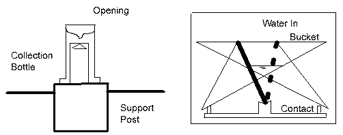
- Recording
tipping bucket gauge (See the following figure)
It senses each consecutive rainfall accumulation when it reaches
a prescribed amount usually 0.01 in or 1 mm of rain. A small calibrated
bucket is located below the rainfall entry port of the gauge.
When it fills to the 0.01 in or 1 mm increment it tips over, bring
a second bucket into position. These two small buckets are placed
on a swivel and the buckets tip back and forth as they fill. Each
time a bucket spills it produces an indication on a strip chart
or other recording form. A record of rainfall depth versus time
is produced.
- Radar
It is used to estimate rainfall intensity because it can detect
any type of raindrops in the atmosphere. The reflection of the
raindrops is determined by electromagnetic energy of the radar
pulse, called echo. The brightness of the echo is a measure of
the rainfall intensity. The strength of reflected radar pulses
is a function of the number and size of the raindrops. As a result,
it can detect light, medium, intense and very intense rainfall.
Because of interference such as building and trees, it should
be used together with rain gauges to provide estimate for areas
not covered by rain gauges. The Meteorological Services of Canada
(MSC) operates 14 weather radars across Canada.
- Satellite
The principal value of remote sensing is its ability to provide
regional coverage and point measurement. Additionally, satellite
communications can be digitized and transfered to computer for
analysis and presentations.
MSC also has
real time access to digital imagery from both geostationary and
polar orbiting satellites launched by agencies in the U.S.
Monitoring
networks are used to determine the spatial and temporal distribution
of rainfall and snow in a regional setting. The spatial variation
of precipitation is due to the fact that precipitation events are
dynamic and moving constantly. The temporal aspect of precipitation
is signficant for rainfall of short and long duration. As the costs
of monitoring can be very high, monitoring networks should be designed
to be efficient and cost-effective. In order to design a cost-effective
monitoring network, the designer should have a comprehensive knowledge
of the system to be monitored, the data to be used, and the level
of detail in space and time.
In Canada,
the MSC publishes precipitation data. Other sources include private
companies, municipal networks and other government agencies.
The minimum
precipitation-gauge densities recommended by the World Meteorological
Organization (1974) for various climatic situations are shown in
the following table. In Canada, the target density is about 25 km
separation between standard precipitation gauges and there are about
200 recording rain gauges. The national network provides large-scale
and long-term records of precipitation and other meteorological
information, which may be used for the planning and design of water
resources structures on a regional scale. In Ontario, there are
currently about 50 recording rain gauges in operation.
Table:
Minimum precipitation-gauge densities recommended by World Meteorological
Organization for various climatic situations (1974) |
| Geographic
Region |
km2/gauge
|
gauge/km2
|
| Small
mountainous islands with irregular precipitation |
25 |
0.04 |
| Temperate,
mediterranean, and tropical mountainous regions |
100-250 |
0.004-0.01 |
| Flat
areas in temperate, mediterrancean, and tropical regions |
600-900 |
0.0011-0.0017 |
| Arid
and polar regions |
1500-10,000 |
0.0001-0.00067 |
For mountainous
setting, a higher density of gauging stations is usually required
to monitor the patterns of precipitation and irregularities based
on topography.
The number
of rain gauges required for watershed monitoring depends on the
nature of rainfall, topography, and the level of analysis (e.g.,
flooding, water balance). Typically, lower density of rain gauges
is required to get representative measurements for long periods
or larger areas. For individual rainfall event measurement, the
rain gauge density may be very high (e.g., 5 km2/gauge). Measurement
of daily rainfall over an area typically requires much lower rain
gauge density (e.g., 18 km2/gauge).
The approximate
lengths of records necessary to achieve stable frequency distributions
are:
- Mountains
- 50 years
- Plains -
40 years
- Coastal
- 30 years
When we have
collected rainfall data from multiple gauges, the average depths
for the whole area can be estimated by a number of techniques: (1)
arithmetic average method; (2) Thiessen Method; and (3) Isohyetal
method.
- Arithmetic
Average Method
This method uses the sum of all precipitation values and divides
by the total number of gauges used. Although this is the simplest
method, it is also the least accurate. It may be satisfactory
if gauges are uniformly distributed and the topography is flat.
- Thiessen
Method
In this method, all the gauge locations are plotted on the map
at an appropriate scale. Next, straight lines are drawn to connect
gauges without crossing any other lines. Each connecting line
is then bisected and a perpendicular is drawn through the connecting
line. Each gauge is near the centre of a polygon whose size varies
according to the spacing of the gauges. The area of each polygon
is then measured and the percentage of the total area for each
polygon is then computed. Finally, the average rainfall over the
basin (Pavg) is computed as
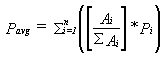
where Ai is the area of each polygon and Pi is the rainfall data
at the centre of each polygon, and n is the total number of polygons.
This method is not suitable for mountainous areas because of orographic
influences.
- Isohyetal
Method
In this method, the rainfall values are used to develop a contour
plot. The average precipitation is calculated between isohyets
(or contour lines) by taking the mid-value between two successive
contours. The area between each successive isohyets is found by
either measuring with a planimeter or counting grid squares. The
average rainfall over the basin (Pavg) is computed as
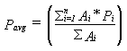
where Ai is the area between contours and Pi is the rainfall data
between isohyets, and n is the total number of areas. This method
is perhaps the most accurate approach for estimating average rainfall.
Meteorological
data can be described by both average observation and extreme events
such as floods and droughts. In order to transform the large meteorological
database into some useful value for planning and design purposes,
hydrologists apply statistical techniques to record data.
The statistical
problems in hydrology are usually associated with the frequencies
with a set of observations. The frequencies of extreme rainfall
events are termed as return period, that is, the average interval
of time between events which equal or exceed the magnitude of the
event of interest.
This section
introduces three types in rainfall analysis: storm event analysis;
intensity-duration-frequency curve; and probable maximum precipitation.
- Rainfall
Hyetograph and Storm Event Analysis
Rain is usually measured in incremental volumes at gauging stations.
These increments take the form of daily volume, or volume at some
other increment of time. It is possible to plot the rainfall volume,
or its equivalent the rainfall intensity, for incremental times
during the event. The result is a plot known as a hyetograph.
The shape of the hyetograph for a particular rainfall event constitutes
the time history of that event.
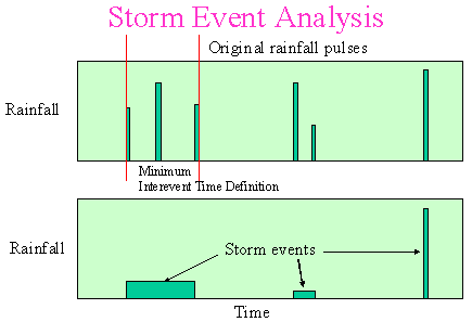
A hyetograph can be used in single event and continuous simulation
anlaysis of rainfall-runoff processes. A long-term continuous
hyetograph consists of a series of rainfall pulses through time.
To separate it into independent storm events, a definition of
the minimum interevent time is required; the reason for this being
so that any two pulses of rainfall can be considered to be belonging
to separated events if the time period between the pulses is longer
than the minimum interevent time. Storm event analysis can be
used to determine the statistics and the probability distributions
of rainfall volume, duration, average intensity, and interevent
time from a long-term hyetograph. Analysis of a number of rainfall
record across Canada (Adams et al, 1983) indicates these characteristics
can be described as exponential density functions. Such statistical
information can be used in statistical analysis of rainfall-runoff
process (Adams and Bontje, 1983).
- Rainfall
Intensity-Duration-Frequency Curves
An observed hyetograph is useful as an indication of the severity
or typical nature of rainfall events, and in calibration of models.
However, a natural event often has little intuitive significance
and no discernable probability, since there are no two events
that are identical. It is therefore useful to seek alternatives
to the direct use of observed rainfall events.
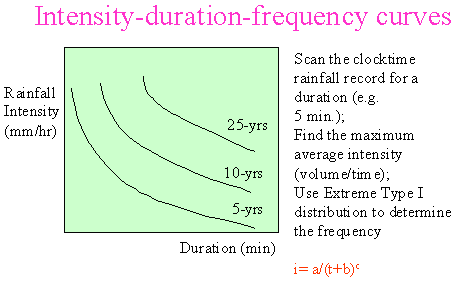
The most
basic definition of a storm event lies in its duration and volume,
and possibly in its peak intensity. In the long term, rainfall
can be assessed according to the frequency of a given duration
and volume occurs. This relationship is defined by curves known
as Intensity/ Duration/ Frequency (IDF) curves.
To generate
an IDF curve, observed rainfall records are scanned for all
instances of a particular combination of duration and volume;
the number of times that combination occurs provides a measure
of likelihood. Assessing the problem in terms of the number
of times a combination is exceeded, provides a probability that
expresses the frequency of exceedance of that combination. Compiling
statistics for all combinations leads to curves that define
the relationship between rainfall event intensity, duration,
and frequency.
The MSC
defines an intensity-duration event for a particular duration,
to, as the annual maximum intensity determined. The duration
selected are arbitrary time periods over which rainfall is totalled
and are not necessarily related to the physical duration of
a storm. The MSC types IDF curves are derived by scanning the
clocktime rainfall record with the event definition: t<=to,
annual max i=(v/to). The extreme annual series is determined,
and a Type 1 extreme value distribution is used to calculate
the frequency of intensity and duration.

where
| i |
= |
intensity
(mm/hr) |
| t |
= |
time
in minutes |
| a,
b, c |
= |
constants
developed for each IDF curve |
Once an IDF relationship is developed for the area of interest,
a certain combination of design intensity and duration can be
determined for a particular frequency of occurrence. The IDF curves
are used extensively in single event analysis of rainfall-runoff
processes.
- Probable
Maximum Precipitation (PMP)
The probable maximum precipitation is the critical depth-duration-area
rainfall relation for a given area and season which would result
from a storm containing the most critical meteorological conditions
considered probable.
These critical
conditions are determined by the analysis of effective precipitable
water, depth of inflow layer, wind, temperature and other factors,
and the historical record of extreme storm events in the region,
topography, season, and location of the area.
Not all rainfall
events generate runoff directly. Minor rainfall events may be retained
completely by aboveground objects such as trees and structures,
soil infiltration, and surface depression. In order to estimate
the direct runoff from rainfall events, it is important to understand
the loss processes and quantify the amount of losses. Unfortunately,
these losses are usually very difficult to quantify the amount and
they vary across time and space. For practising hydrologists and
engineers, some form of approximation of the hydrologic losses may
be required. These approximation may be based on actual field measurement,
previously reported data from similar catchments, and computer simulation
of the physical processes involved.
Interception
refers to the precipitation that wets and adheres to aboveground
objects such as trees and buildings and finally returns to the atmosphere
through evaporation. It is a function of storm eharacter, the species,
age and density of prevailing plants and trees, and the season of
the year.
Usually about
10-20% of the precipitation that falls during the growing season
is intercepted and returned to the hydrologic cycle by evaporation.
Interception during rainfall events is commonly greater than for
snowfall events. Estimates of losses to gross precipitation through
interception can be significant in annual or long-term models, but
for heavy rainfalls during individual storm events, accounting for
interception may be unnecessary.
Most interception
loss occurs during the initial storm period and the rate of interception
rapidly decreases to zero. In addition to trees, forms of vegetation
can also intercept large quantities of water.
Depression
storage refers to the precipitation which is trapped in numerous
small depressions. It is a function of the land form and local land-use
properties and it varies widely in size, degree of interconnection,
and contributing drainage area. Depressions can be considered as
small reservoirs. Depression storage is sometimes assumed to be
a constant throughout the storm events. Rainfall is assumed to fill
up depression storage before runoff begins.
Water evaporation
can be from the soil as well as open water bodies to the atmosphere.
This is a significant process in the hydrologic cycle because it
supplys the atmosphere with water moisture for the subsequent rainfall
events. It is significant over large bodies of water such as lakes,
reservoirs, and the ocean.
Evaporation
occurs when a molecules of water moves quickly enough to break away
from other water molecules at the water-air interface. In order
for the water molecules to break away, the latent heat of evaporation
(540 calories per gram of water at 100 C) is required. Water molecules
also enter the water from air through the condensation process.
The net exchange of water molecules at the air-water interface is
determined by the rate of evaporation and the rate of condensation.
Evaporation will proceed when suffieient energy is available (e.g.,
heat in water or solar radiation) and when the vapour pressure above
the water is less than the saturation vapour pressure.
Evaporation
from water surface is a function of
- Solar
radiation
Solar radiation provides energy that can be stored as heat in
the water. This latent heat is transformed to kinetic energy as
water molecules evaporate.
- Temperature
Although temperature is not directly related to evaporation rate,
it controls the saturation vapour pressure and affects the difference
in vapour pressure between the surface and the bulk air above.
- Humidity
The rate of evaporation is directly proportional to the difference
between actual humidity in the air above the water the saturated
humidity that occurs at a specified temperature.
- Wind
Wind can remove the more humid air above the water surface and
replace it with dry air that enhances the rate of evaporation.
However, the maximum evaporation rate is controlled by factors
other than wind speed and increasing wind speed above a certain
value would cause no increase in evapoation.
- Water
body depth
Shallow lakes warm up more quickly and follow seasonal temperature
trends more closely than do larger lakes. Shallow lakes with a
small water volume show high evaporation rates during summer months
and lower evaporation rates during the winter period. However,
deep lakes with large volumes generally lay behind atmospheric
temperature trends and have sufficient water volume to release
the stored energy in cooler months, permitting evaporation in
the absence of sufficient solar radiation. Higher evaporation
rates may occur in winter months rather than in summer months
in large lakes.
- Size
and shape of water surface
As dry air travel across a large lake, the vapour pressure or
water content of the air will begin at low values on the windward
side of the lake and become progressively more humid as it proceeds
across the lake surface. Evaporation rates will be highest on
the windward side of the lake but will decrease as the air mass
moves across the lake and the relative humidity increases.
The average rate of evaporation over a lake will depend on the
relationship between the prevailing wind direction and the orientation
of the long axis of a lake. If the prevailing wind moves along
or parallel to the long axis of a lake, the vapour pressure will
increase to a greater content and therefore the rate of evaporation
will decrease towards the leeward side of the lake. As a result,
the maximum rate of evaporation from the lake occurs when the
air mass is in contacct with the lake for the shortest period.
If the prevailing wind crosses the lake along the short axis,
the air does not pick up as much moisture and the rates of evaporation
remain higher.
- Water
quality
Evaporation from a free water surface will decrease proportionally
to increasing salintiy. For instance, if the total dissolved solids
of the water increases by 1%, the evaporation form that water
will decrease by 1%. This caused by the tendency of dissolved
ions in water to hold water molecules more closely together.
Evaporation
from soils is a function of
- Soil
moisture content
This is the most significant factor. As the moisture content of
the soil decreases, the evaporation rate will decrease as the
dry soil on top acts as a barrier to provent evaporation of water
at greater depth.
- Water
table depths
Maximum evaporation rates will occur when the water table is at
the ground surface. As the water table depth increases, the rate
of evaporation decreases.
- Soil
characteristics
Soil characteristics affect the rate of evaporation and the availability
of water to evaporate. In general, fine-grained soils hold more
moisture and have a greater reservoir of water for evaporation.
Additionally, the finer-grained soils have a greater capillary
effect and transport water from greater depths to be evaporated
at the surface. As a result, areas with fine-grained soils are
subject to greater evaporation than areas with coarse-grained
soils.
- Soil
colour
Materials with a darker colour absorb more solar radiation than
ligher-coloured materials. Dark soil will absorb more energy and
be subject to greater evaporation rates than light soils.
- Vegetative
cover
Vegetative cover tends to decrease the amount of evaporation compared
to that of a vare soil. Plants provide shade on the soil surface
and decrease the amount of solar radiation reaching the ground.
Plants also provide a wind block that reduce the wind speed at
the soil surface and reduce evaporation rates. Plant can also
increase the relative humidity close to the ground surface through
transpiration and decrease simple evaporation from the soil surface.
For open bodies of water, evaporation can be 100% while for soils
it varies from a high 100% when the soil is highly saturated to
essentially zero at stages of very low moisture content
Transpiration
is the evaporation of water from the vascular system of plants into
the atmosphere. Water is taken up by plant roots in the soil, moves
to the branches and leaves where evaporation takes place. The amount
of water used for plant growth is negligible compared to the water
that is transpired. Transpiration occurs not because the plant is
breathing, but because of the difference in vapour pressure inside
the leaf and in the air outside.
Transpiration
is controlled by the same factors that control simple evaporation
from water surface. These include:
- Solar
radiation
The solar radiation to plant leasves controls the opening of the
stomata and controls transpiration. Maximum transpiration rates
occur during daylight hours and in the summertime with minimum
rates at night and cooler weather.
- Air
temperature
Transpiration shows a maximum rate at an optimum temperature of
a plant species.
- Air
humidity
The difference in vapour pressure within the stomatal cavities
of the leaves compared to the vapour pressure in the outside air
is a driving force for transpiration.
- Wind
and air turbulence
Wind and air turbulence removes the saturated air and increase
the vapour pressure gradient between the air inside the leaves
and the surrounding air.
- Vegetation
When stomata are closed, virtually no transpiration can occur.
When they are open, the climatic factors control the rate of evapotranspiration.
Length of daylight, air temperature, and higher humidity control
the length that stomata remain open.
Lighter colour for plant leaves reflect solar energy and reduces
transpiration. The more dense a vegetative cover, the more leaf
surface area will be available for transpiration. Broader leaves
provide greater surface area for evaporation. Transpiration will
increase with the growth of plant. Plants with deep root types
supply more water for transpiration.
- Soil
moisture content
The availability of moisture in the soil zone will control the
amount of tranpiration that can occur.
- Storage
capacity
Fine-grained materials will store more water than coarse-grained
materials. As a result, more water is available in fine grained
soils.
- Capillary
tension
Finer-grained soils can hold greater amounts of water by capillary
action than coarse-grained soils.
- Soil
permeability
Higher soil permeabilities permit faster replenishment of water
to the root zone and lower permeabilities decrease the rater of
replenishment.
- Depth
to the water table
The depth of the root zone for different plants ia a very important
controlling factor for evaporation. The change in water levels
as a result of plant uptake of water can be used as a direct measurement
of evapotranspiration rates.
Potential evapotranspiration
is the rate at which evapotranspiration would occur from a large
area uniformly covered by vegetation with unlimited access to soil
water and disregarding heat flow and storage effects. It cannot
exceed free water evaporation under similar climate.
Infiltration
is the entry of waters into the ground. The rate and quantity of
water which infiltrates is a function of soil type, soil moisture,
soil permeability, ground cover, drainage conditions, depth of water
table, and intensity and volume of precipitation (Wanielista et
al. 1997). The infiltrated water replenishes soil moisture, recharges
groundwater aquifers, and ultimately augment base flow in streams.
After water
crosses the surface interface, its rate of downward movement is
controlled by the transmission characteristics of the underlying
soil profile. The volume of storage available below ground is also
a factor affecting infiltration rate. The major influencing factors
of infiltration are soil type and moisture content. The soil type
characterizes the size and number of passages through which the
water must flow while the moisture content sets the capillary potential
and relative conductivity of the soil.
Infiltration,
together with other hydrologic losses, determines the rate of runoff
from a catchment.
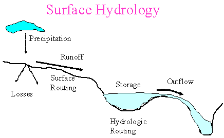
Runoff analysis
is a very important component of surface hydrology. Although the
process appears to be simple as it occurs frequently around us,
the relationship between precipitation and runoff is affected by
various storm and basin characteristics and is very complex. Various
techniques which range from simple lumped models to sophisticated
continuous simulation models have been developed for runoff prediction.
Simple lumped models may be suitable for planning analysis of runoff
while continuous simulation may be appropriate for design analysis.
Runoff occur
when precipitation exceeds the hydrologic losses. It starts with
overland flow which is then collected and transported by various
drainage pathways such as streams and storage reservoirs and eventually
discharged to receiving water bodies such as rivers and lakes. The
precipitation-runoff process is complex as it involves numerous
flow routing interactions in the watershed. Additionally, the spatial
and temporal characteristics of precipitation also make the prediction
of runoff a challenge to engineers.
Watershed characteristics
which affect runoff include:
- Stream
patterns
Stream patterns affect the pathways of runoff at a watershed.
Runoff from different parts of a watershed will interact with
each other in accordance with their runoff pathways
- Geomorphology
of drainage basins
Both large scale and local geologic activity and structure affect
the storage and movement of surface waters. The nature of land
forms determines drainage pattern which in turn also affects the
surface geometry through the process of erosion.
- Overland
flow lengths and stream lengths
Overland flow length is the distance from the ridge line or
drainage divide, measured along the path of surface flow which
is not confined in any defined channel, to the intersection of
this flow path with an established flow channel.
The flow length to any point is the sum of overland flow lengths
and stream lengths. The flow length is important in the application
of Rational Method of runoff peak calculations.
- Areal
characteristics
Drainage area has been used as a parameter in regression models
of precipitation-runoff process. As drainage basins increase in
size, they become longer and narrower. Drainage density is defined
as the ratio of total channel segment lengths cumulated for all
stream orders within a basin to the basin area.
- Channel
and Basin Gradients
The slopes of a drainage basin and its channels have a strong
influence on the runoff process as they affect the runoff rate
- Area-elevation
relation
The distribution of area between contour in a drainage basin
is an important characteristics as it relates to the storage and
flow characteristics of the basin.
A stream hydrograph
is a continuous plot of discharge rate versus time at a point along
a stream during a storm event. Streamflow is usually measured by
stage (i.e., depth). Therefore, it starts with the plot of stage
versus time. Then, it is transformed into flow versus time using
a rating curve (i.e., stage-discharge curve) at the point of measurement.
Streamflow
hydrographs provide information on peak flows, time distribution
of flows, the total flow volume over a certain duration which can
be used to determine flooding potential and size reservoirs, storage
tanks, detention ponds, and other facilities.
A hydrograph
has four components:
- direct
surface runoff;
- interflow
- groundwater
or base flow;
- channel
precipitation.
The rising
limb is called concentration curve, the region in the vicinity of
the peak is called the crest segment, and the falling limb is called
the recession curve. The shape of a hydrograph is a function of
precipitation pattern characteristics and basin properties.
In general,
there is a baseflow component which are considered to be normal
day-to-day flow. The runoff component can be divided into the abstraction
and direct runoff. If baseflow and abstraction are removed from
the streamflow hydrograph, the resulting hydrograph is called direct
runoff hydrograph. The main component to be separated from the streamflow
hydrograph is the baseflow.
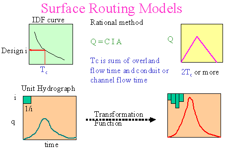
There are two
main approaches in modelling rainfall to runoff. Deterministic models
assume the same inputs will produce the same outputs. On the other
hands, stochastic models assume both inputs and outputs are random
variables and the same inputs may produce different outputs. However,
the preferable modelling approach is a function of time, budget,
expertise of the users and the purpose of the analysis. The following
diagram shows two common deterministic models for rainfall-runoff
transformation.
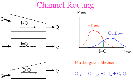
| Hydrologic
Channel Routing |
|
Hydrologic
routing is used to simulate the temporal and spatial variations
of a flood wave as it traverses a river reach or detention reservoir.
In hydrologic routing, the equation of continuity and a linear or
curvilinear relation between discharge and storage within a river
and reservoir are used.
When a flood
wave enters a river section, the water surface within the section
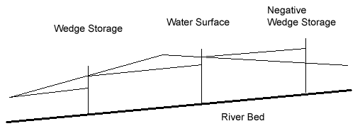
is not always parallel to the channel bed. The storage in a channel
can be considered as a combination of prism storage and wedge storage
as shown in the following figure. The prism storage is the volume
of water that would exist if the flow were uniform at the downstream
depth. The wedge storage is the volume of water between the actual
water surface profile and the top surface of the prism storage.
The wedge storage increases the flood volume during the rising stage
and decreases it during the receding stage. Thus, the storage-discharge
curve of the river section is a loop reflecting the rising and falling
stages. Additionally, local inflows and seepage within the river
section should be accounted for in hydrologic river routing.
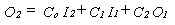
Hydrologic
river routing are all based upon the following equation of continuity:

where I is
the inflow rate to the reach; O is the outflow rate from the research;
and (dS/dt) is the rate of change of storage within the reach. This
lecture introduces the Muskingum Method.
Muskingum
Method
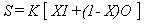
In order to solve the above equation, a relationship between
storage and inflow and outflow is required. This method utilizes
the following relationship:
where K is
the storage time constant for the reach and X (or c in the textbook)
is a weighting factor that varies between O and S. Substituting
Eq. (2) into Eq. (1) and denote subscripts 1 and 2 as the beginning
and ending times, Eq. (1) becomes
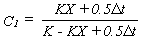
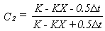
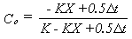
Values of K
and X (or c in the textbook) for this method are commonly estimated
using K equal to the travel time in the reach and an average value
of X equal 0.2. If inflow and outflow hydrograph records are available,
they can be used to estimate K and X.
This method
works best for
- slowly changing
flows,
- streams
with small slopes where the storage-discharge curve is approximately
linear,
- delta t
is much smaller than the travel time of flood wave and small enough
to ensure linear variation of inflows and outflows. A rule of
thumb of delta t is given by

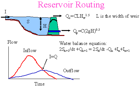
| Hydrologic
Reservoir Routing |
|
A flood wave
which passes through a storage reservoir is delayed and attenuated
as it enters and spreads over the reservoir surface. Water that
is stored is then released through either a controlled or uncontrolled
outlet. To route a flood wave through a nonlinear reservoir, the
storage-outflow relation and the continuity equation are combined
to determine outflow and storage at the end of each time step. Thus,
both the elevation-storage curve and elevation-discharge curve must
be developed.
Elevation-storage
relation can be estimated by
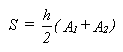
where A1 is
the surface area of the reservoir when h equals zero and A2 is the
surface are of the reservoir when h equals the depth of flow.
Elevation-discharge curve is assumed to be unique for a reservoir
and is described by the following equations:
- Uncontrolled
weir outflows
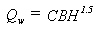
where Qw is the weir discharge rate; C is the weir coefficient;
B is the weir length; and H is the hydraulic head above the weir
crest.
- Controlled
orifice outflows
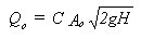
where Qo is the orifice discharge rate; C is the orifice coefficient;
Ao is the orifice area; g is the gravitational constant (9.81
m/s2); and H is the depth of water above the centre line of orifice.
The hydrologic
volumetric balance equation can be rearranged as follows:
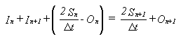
where the unknowns are the terms on the right side. Routing time
(delta t) should not be too short or too long.
The procedure
for hydrologic reservoir routing is listed below:
- Develop
elevation-storage and elevation-discharge curves and combine them
to a storage indication curve (i.e., a plot of (2S/delta t + O)
versus O).
- Knowing
In, In+1, Sn, and On, compute the left hand side of Eq. (11),
i.e., (2Sn+1/delta t + On+1).
- Determine
On+1 from the storage indication curve (i.e., a plot of (2S/delta
t + O) versus O).
- Compute
(2Sn+1/delta t - On+1) by substracting 2On+1 from (2Sn+1/delta
t + On+1).
- Add In+1,
In+2 and (2Sn+1/delta t - On+1) to determine the left hand side
of Eq. (11) and to back to step (3) for the next time step.
|