|


|

|
Introduction
More than 50 years
ago, Ontario recognized the importance of watershed planning and established
conservation authorities whose functions were to promote water management
on a watershed basis. Although flooding and erosion issues had dominated
water management for many decades in Canada, we have now recognized that
water management has many other objectives such as water quality, ecological
health, terrestrial and aquatic resources, etc. In order to manage our
water resources effectively, we should apply an ecosystem approach in
water management. The logical sequence of water management planning should
be watershed plans, subwatershed plans, and site plans and these plans
should be integrated with municipal land use planning process. This chapter
introduces the concept and framework of water management planning and
presents two water management studies.
Before we discuss
about water management planning, we have to understand the importance
of ecosystem in water management planning. An ecosystem comprises both
biological (e.g., bugs, fish, animals, etc.) and physical components (e.g.,
air, water, soil, etc.) and their interactions characterize the ecosystem.
Ideally, an ecosystem should be almost self-contained. In reality, all
ecosystems interact with the surrounding environment. In order to study
an ecosystem, we try to delineate ecosystem so interactions with outside
environment are minimized.
A water ecosystem
is all water and living organisms and their interaction and relationship.
However, the land adjacent to water also plays an importance role in a
water ecosystem. For instance, trees along a watercourse provide shade
and food to aquatic organisms in the watercourse. Additionally, whatever
happens on the land eventually enter the water ecosystem through surface
runoff. Thus, watershed planning encompasses both land and water ecosystems.
An ecosystem approach
to water management should protect the linkages among biological and physical
components of the ecosystem and allow for sustainable development within
a watershed. This approach is superior to the traditional river basin
planning which focuses on water utilization and water damage reduction.
Although we cannot quantify every ecological process in an ecosystem,
some qualitative evaluation of cause and effect may allow us to impute
the potential impacts due to urbanization.
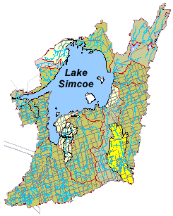
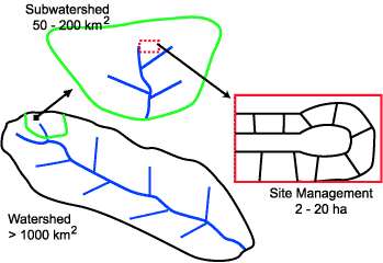
| A
watershed is defined as the land area drained by a river and its tributaries.
It is used to define the surface water drainage boundary. The concept
of watershed originates from surface hydrology where a river is assumed
to be affected primarily by its surface drainage area. In fact, both
surface and subsurface hydrology define a river and the importance
of subsurface hydrology should not be overlooked. For instance, river
baseflow is supplied primarily by ground water. However, it is generally
assumed that the subsurface watershed be similar to the surface watershed.
The following diagram demonstrates an example of watershed, subwatershed,
and site boundaries. |
 |
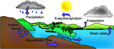 |
The
main process in a watershed is the hydrologic cycle which summarizes
the movement of water among surface water, air, land, and ground water.
This process governs the physical, chemical, and biological characteristics
of water ecosystems in a watershed. |
| One
of the driving forces for water management planning is development
pressure. In the Greater Toronto Area, we have seen un-sustainable
developments which emphasize maximum economic return rather than sustainable
environment. The end result is that residents are faced with degraded
natural and social environment. In order to allow sustainable growth
in any municipalities, it is important to develop water management
plans so future urban development can be allowed without significant
harm to the environment. In assessing ecosystem system response to
urbanization, the most logical planning boundary is the watershed. |
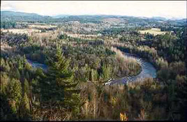 Natural Watershed
 |
|
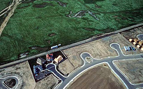 Urbanized Watershed
 |
Fully urbanized municipalities
also may be interested in water management planning which focuses on rehabilitation
of degraded urban environment and sustainable re-development. In urban
retrofit planning, the primary planning boundary should also be watershed.
Sometimes, natural watershed boundary in fully urbanized area may be altered
and a watershed may be delineated with respect to sewershed boundary.
Water plans use an
integrated approach to minimize impacts associated with human land use
and enhance the natural environment wherever possible. Ultimately, this
approach protects the resource, allows for more informed planning decisions,
involves stakeholders, speeds up approvals, and saves money to all involved.
| Watershed
Management Plan |
|
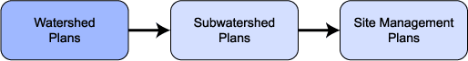
It is essential that
water management plan be prepared on a watershed basis. The logical sequence
of water management plan should be watershed plan, subwatershed plan,
and site plan. The relationships between these planning levels are illustrated
in the following diagram.
A watershed plan
is:
- A document for
the management of water, land/water interactions, aquatic and terrestrial
life and resources. It is often initiated either by local municipalities
or conservation authorities who recognize either an existing or potential
deterioration of the environment due to existing and future urban development.
Funding may be shared between municipalities, conservation authorities,
provincial ministries, and developers.
- Its goal is to
protect, enhance, and rehabilitate water resources in relation to existing
or changing land use.
- The fundamental
process for water management is the hydrologic cycle that integrates
physical, chemical, and biological processes of the ecosystem in the
watershed.
- This plan provides
management goals, objectives, control targets, and environmental constraints
and this information should be integrated with either land use or rehabilitation
planning and decisions.
- One of key components
of watershed planning is public involvement and consultation.
The first step of
watershed planning process is to develop water management goals and objectives.
The differences between goals and objectives are sometimes confusing.
My opinion is that there should be only one watershed goal and a number
of water management objectives. The water management goal for a watershed
may be to protect and sustain whatever is essential to the watershed health
and rehabilitate whatever is degraded.
In order to reach
the water management goal, we may need to achieve a number of objectives
relating to water quantity and quality, ecological health, sustainable
development, and socio-economic enhancement. Some of these objectives
may be complementary or competitive. Thus, some compromises and tradeoffs
may be necessary to find the best water management policies and strategies.
For instance, conservation of green space is competing with urban residential
development. A compromise may be that the essential green space is preserved
while urban residential development may be allowed in less significant
green space areas.
Achievement of water
management objectives should be measured with respect to indicators and/or
parameters. For instance, the Toronto Wet Weather Study has 12 objectives
and each objective is measured by its respective indicators and/or parameters.
Table 1 shows some examples of the criteria/indicators in the Toronto
Study.
|
Objectives
|
Indicators
|
Parameters
|
| Healthy Aquatic
Communities |
Representative
aquatic communities |
Indicator species/communities |
| Reduction of
fish advisories |
Contaminant
guidelines |
Sportfish tissue
contaminants |
| Reduction of
erosion impacts on habitats and property |
In-stream erosion
potential |
In-stream erosion
index |
| Rehabilitation
of natural hydrologic cycle |
Water budget |
Total runoff
volume |
| Re-establishment
and rehabilitation of natural features |
In-stream corridors |
Barriers (structures,
velocity/depth, chemical) |
| Virtual elimination
of toxics through pollution prevention |
Spill prevention/emergency
response |
Number of reported
spills |
| Meeting Federal,
provincial, municipal sediment and water quality guidelines |
E. Coli guidelines |
5 day geometric
mean |
| Elimination
of Sanitary Sewer Discharges |
CSO/SSO overflows |
Number of overflows |
| Improved water
quality for body contact recreation |
Beach closures |
Number of days
closed |
| Improved aesthetics |
Algae, turbidity,
odour, fish kills |
Number of complaints |
| Reduction of
basement flooding |
Reported incidents |
Number of complaints |
| Reduction of
infiltration/inflow |
Sewer flows |
Dry weather
flow (sanitary/storm) |
| Protection of
life/property from flooding |
Protection of
life/property |
Ratio of site
protected/site identified |
Table 1: Examples
of the objectives, indicators and parameters of the Toronto study
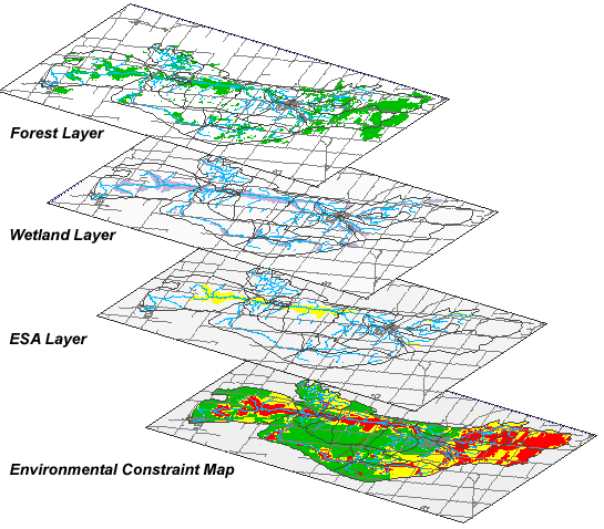
Assessment of existing watershed conditions requires ecological mapping
of the watershed features (e.g., geology, ESA, topography, land use, rivers
and lakes, fishery, etc.). Such a task can be handled efficiently with
the use of Geographic Information System. However, if sufficient and compatible
digital data of the watershed features are not readily available, this
may be the most expensive and time-consuming task of the whole planning
process. Nevertheless, these maps will assist the identification of sensitive
areas for protection and less sensitive areas for development.
Watershed wide policy
(Fig. 1) can be developed by analyzing the ecological impacts of various
development scenarios and evaluate their achievement of watershed objectives.
Comparison of alternative development scenarios requires that relative
weights be assigned to watershed objectives and a consistent rating system
for various levels of achievement be adopted. The final development scenario
and the associated watershed wide policy (which maximizes the overall
achievement of watershed objectives) will be recommended.
- Will take
a broad ecosystem approach to water, water related natural features,
terrestiral resources, fisheries, water dependencies/linkages
and valley/open space systems.
- Will provide
watershed wide policy and direction for:
- Ecological
integrity and carrying capacity
- The
protection of valley system and green space planning
- The
management of water quantity and quality
- Acquifer
and ground water management
- Fisheries
management
- Rehabilitation/enhancement
programs
- A framework
for implementation of watershed policies and programs
- Regional
opportunities and constraints
- Document
servicing needs/availability of water/sewage
- Will delineate
subwatershed planning areas
- Present
target, goal and objectives for subwatershed
|
| Plan recommendations to
be input to official plans |
The watershed planning
process will also delineate subwatershed planning areas, set the associated
control target, goal and objectives, and the priority of subwatershed
planning study.
The whole watershed
planning process should involve publics and stakeholders in every step
so the final watershed plan can be acceptable to most people in the watershed.
As discussed before, compromises and tradeoffs are necessary to maximize
the overall achievement of watershed objectives.
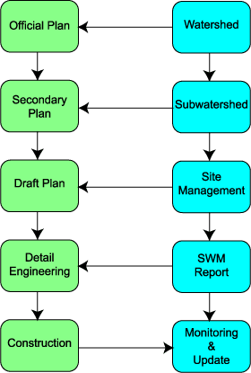
Where a watershed
plan has been prepared, all land use planning decisions should be carried
out in accordance with the recommendations of the watershed management
plan. In Ontario, the primary planning document in the municipal land
use planning process is the official plan. It sets the municipality's
goals and objectives for land uses within its jurisdiction and provides
specific policy direction which guides land development in accordance
with provincial policies and guidelines. An official plan can reflect
the broad directions, goals and targets established in the water management
plan. The relationship between water management planning and land use
process is illustrated in the following flow diagram.
Municipal Land
Use Process

|