|
CASE
STUDIES
The Mimico
Creek Watershed Stormwater Retrofit Plan
A case study
of the fully urbanized Mimico Creek watershed in the City of Toronto
is used as a demonstration of the stormwater planning methodology.
This creek drains an area of 40 square kilometres in the former
City of Etobicoke along the western edge of Toronto, and encompasses
a spectrum of urban land uses. Selection of a study site committed
the project to working with the host municipality and its data and
information-technology resources. Etobicoke had previously demonstrated
a willingness to participate in stormwater pollution abatement research
and was regarded as a typical urban environment in that it has digital
geographic records of its municipal infrastructure. Issues associated
with conversion and compilation of data records and liaising with
municipal officials, in a GIS environment analogous to the situation
in many other municipalities, was seen to broaden the applicability
of the tool that was developed.
During the
period of this study the new City of Toronto was created, combining
six former local municipalities and the former Metropolitan Toronto
into a single entity. Formerly-disparate responsibilities (such
as differentiated Metro and local roads) became consolidated, however,
this process had not yet affected the GIS data records used in this
study. Etobicoke=s digital geographic data records serve the needs
of the Works, Planning and Parks Departments, primarily in terms
of mapping. The records are spatially separated (tiled) but thematically
aggregated into map series such as Topography (Series 1- trees,
buildings, fences, rail lines), Utilities (Series 2 - catch basins,
manholes, poles, lights), Contours (Series 3 - lines and spot elevations),)
Lot Lines (Series 4 and PIX 1), and Streets (PIX 11 - two-sided
roads). The geographic coordinates of the points and linear vectors
representing features have been standardized, in units of the three-degree
Universal Transverse Mercator projection (3E UTM) , based on the
1927 North American Datum (NAD27). All Works Department records
had been created and stored using the Bentley Microstation GIS.
Attribute records were not extensive except for roads which had
been stored as standard database (dbf) files, but had not been linked
to digital geographic representations of their locations. Some additional
records were only available as hard copy (paper maps of land use,
parks, soils and 13 Akey maps@ of sewersheds) at different scales,
to different standards and for diverse purposes. Part of the Mimico
Creek basin crosses the Etobicoke boundary with a neighbouring municipality
(the City of Mississauga) where the data standards are not the same
as in Etobicoke or the new City of Toronto. This was not the ideal
situation for geographic analysis, however, it is regarded as typical
of municipal records and watershed-based planning, and therefore
appropriate for realistically developing the planning tool to be
targeted to other Ontario municipalities.
Due to the
extensive data conversions and anticipated polygon analyses, Environmental
Systems Research Institute (ESRI) products (Arc/Info and ArcView)
were selected as the GIS for this project. Other software products
may serve these purposes, however this was the GIS platform of choice.
These packages have particularly strong capabilities for the geographic
data processing tasks involved in this project: for reprojecting
data to a common standard, for assessing data integrity , for aggregating
polygon features such as sewersheds, soils and land use etc, for
isolating geographic features based on their attributes or by overlaying
different thematic layers, for ensuring the fidelity of the synthesized
features, and for the ease of data extraction for engineering evaluations.
The ESRI data structure is complex but permits both the interactive
processing of geographic and attribute data (ArcView) and the high-order
spatial data analysis (Arc/Info) required for this project. Unlike
map-based systems, the ESRI data model enables themes of data (called
coverages) to be isolated, and treated as a unit. Roads for instance
would be isolated as one coverage, sewersheds as another and outfalls
as a third. Logical connectivity (topology) between features is
built into the coverages, enabling a high degree of fidelity with
the reality of these types of features on the ground.
The initial
tasks involved isolation of the available Microstation (.dgn) records
from municipal files and supplementing these with data digitised
specifically for this project (also using Etobicoke=s Microstation
software, and Etobicoke=s standard projection and datum). These
map-sheet files were clipped to the limits of the Mimico Creek watershed,
then exported and converted to feature-based and topologically-structured
Arc/Info coverages. Most themes required joining into single coverages
(e.g. combining of Etobicoke and Mississauga data, merging of the
13 Storm Key Plans, etc). Tables of feature attributes were subsequently
linked to these GIS files. The specific data coverages used in this
study included:
C sewersheds - heads-up digitised from Storm Key Plans, keyed-in
runoff?coefficient attribute
C outfalls - 106 points heads-up digitised from Storm Key Plans,
attribute fields keyed in
C roads - PIX 11 heads-up digitised, sewershed-delimited topologically-structured
centre-lines; linking of Aroads@ in the attribute database to road
segments
C watercourses - Series 1 (Topography) heads-up digitised, topologically-structured
C open spaces - heads-up digitised, topologically-structured; attributes
keyed in
C utilities easements - Series 1 & 2, topologically-structured;
attributes keyed in
C buildings - Series 1 (Topography), topologically-structured polygons
C soils - scanned then topologically-structured, texture attribute
keyed in
C elevation - conversion of approximately 40 000 spot elevations
C land use - heads-up digitised, topologically-structured
C lots (PIX 1) converted to topologically-structured
C downspout areas heads-up digitised, topologically-structured
The analytical
capability of GIS comes at the cost of the efforts required to assure
data fidelity and consistency (Banting, 1992). The exercise of data
conversion, compilation, topological structuring and integrity checking
represents a significant up-front set of endeavours. The benefit,
however is that GIS represents the Mimico Creek basin stormwater
management system, enabling evaluation of the alternative RSWMP
scenarios for meeting the retrofit goals and objectives.
Step
1 - Definition of Storm Water Retrofit Goals and Objectives
In the Mimico
Creek watershed, the environmental and economic goals of storm water
quality management were defined as follows:
C Environmental goals
$ to rehabilitate and enhance the existing hydrologic cycle; and
$ to rehabilitate and improve the existing runoff quality.
C Economic goals
$ to integrate the storm water quality management strategy with
municipal capital works and maintenance programs; and
$ to minimize the cost of storm water quality management in urbanized
areas.
As there has
been no comprehensive watershed plan developed for this watershed,
no numerical storm water control targets were set for the analysis.
The purpose of this case study was to determine the achievable control
targets and their associated costs. The environmental and economic
goals were then defined by the following objectives:
$ to reduce the existing runoff volume;
$ to reduce the existing total suspended solids loading; and
$ to use cost-effective RSWMP=s.
Step
2 - Identification of Appropriate RSWMP=s
A number of
RSWMP=s have been tested or proposed in the Greater Toronto Areas:
downspout disconnection (MOEE, 1994), oil/grit separators (MOEE,
1994), storm water exfiltration systems (Li et. al., 1997a), swales
and ditches (Li et al., 1998), retrofit quantity ponds, storm water
quality ponds (MOEE, 1994), and off-shore flow balancing systems
(Aquafor, 1994).
Li et al. (1997a)
describe the conditions under which various RSWMP=s are considered
feasible. Downspout disconnection for lot level runoff disposal
is considered potentially effective if slope gradients are gentle,
soils are permeable, the groundwater table is deep, and there is
open space available on individual lots. For oil/grit separators
to be contemplated as an RSWMP option, the land use should be commercial
or industrial; for cost effectiveness existing or proposed storm
sewers should have construction impending. Storm water exfiltration
systems can be considered for local roads in residential areas where
the soil is permeable. Swales and ditches (Li et al., 1998) may
replace storm sewers where there is sufficient right of way and
maintenance of existing swales and ditches can be considered to
be a stormwater quality measure. Retrofit of storm water quantity
ponds is only feasible where they currently exist, where there is
sufficient space to accommodate the water quality function, where
public awareness can be assured and where access for maintenance
can be provided. No quantity ponds were found in the study area
so this option was eliminated from further consideration. New storm
water quality ponds require open space, with sufficient area off-line
to capture the first flush of runoff events. Concerns regarding
compatibility with adjacent lands are similar to those of retrofit
ponds. An off-shore flow balancing system (Aquafor, 1994) requires
specific environmental conditions in the receiving waters of the
watershed. A sheltered embayment devoid of significant aquatic ecosystem
function is required. The downstream position and other concerns
eliminated this option from further consideration for Mimico Creek.
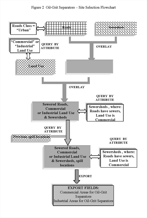
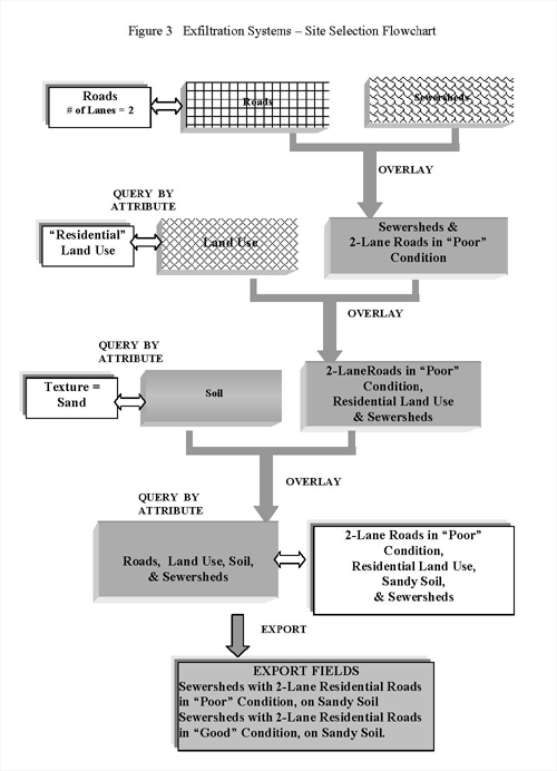
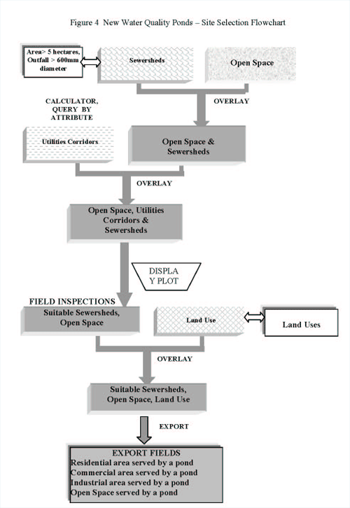
To identify
suitable RSWMP=s, values for each of the screening criteria were
derived through GIS processing of the thematic coverages. Figure
X.2 to X.5 illustrates the screening procedure of downspout disconnection,
oil/grit separators, exfiltration systems, and water quality ponds.
Prominent among these processing tasks were the Aquery by attribute@,
Aoverlay@, and Acalculator@ functions. Query by attribute selects
records from a thematic coverage based on specified value ranges
for a set of attributes, for instance all polygons with a residential
land use. Overlay combines two topologically-structured coverages,
merging the features of each into new features. Overlay of buildings
onto lots creates a new coverage with built and open portions distinguished
on a lot by lot basis. Attributes of the original coverages are
also joined. Calculator functions permit aggregation, measurement
and export of derived values, so that for each RSWMP, the number
of lots, drainage areas or length of roads that are suitable for
its use are identified and measured.
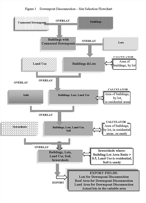
Downspout Disconnection.
For the downspout disconnection RSWMP, Li et al., (1997a) indicate
that the roof to lot area ratio be less than 0.5, the land use residential,
and the soil sandy. Using Arc/Info, the buildings were overlaid
on lots, preserving each coverage=s Apolygon area@ attribute. (Arc/Info
automatically determines the area of polygon features and stores
this as an attribute field.) For lots with multiple buildings the
calculator function summed buildings within the lot and posted this
sum to the attribute table. A new field was then created indicating
the ratio of building area to lot size. Lots were then overlaid
onto land use and soils polygons, as well as onto sewersheds. The
resulting coverage consisted of 830 polygons, each with the required
attribute fields -- building to lot area, land use and soil texture,
as well as a link to the sewershed coverage. The ArcView query function
then isolated the 69 sewersheds which met all of the prescribed
criteria, and generated an export table summarizing drainage area,
roof area and the number of lots in the area identified as suitable
for downspout disconnection.
Oil/Grit Separator.
This RSWMP is suitable in commercial and industrial areas, where
a storm sewer is present. Among the attributes of roads is a classification
field which identifies the presence of storm sewers. Pre-processing
had redefined road features as the segment contained within an individual
sewershed. Aggregation of all road segments within sewersheds enabled
use of the calculator function to proportionalise the sewershed
areas suitable and unsuitable for separator treatment. Overlay of
sewersheds with land use isolated commercial and industrial areas.
For each sewershed, the commercial and industrial drainage areas
suitable for oil/grit separators were calculated and tabulated.
Exfiltration
Systems. Identification of areas in which storm water exfiltration
systems can be considered suitable was based on a series of overlays
and queries. The ArcView query function was initially used to isolate
from the roads database, those segments requiring reconstruction
in the next 5 years (Apoor roads@), then constraints regarding width
(2 or fewer lanes), land use (in residential areas), and soil (sand)
were imposed. Then overlay and the calculator function enabled creation
of export tables of sewershed-based summaries. These were comprised
of the length of suitable roads and the proportionalised suitable
areas where exfiltration systems could be considered.
New Quality
Pond. Sites at storm-sewer outfalls were targeted for the construction
of a new stormwater quality pond. Suitable sites were regarded as
those where the outfall diameter was over 600mm, and the drainage
area exceeded 5 hectares. Each of the outfalls had been linked to
its sewersheds via an attribute field created during data capture.
By aggregating sewersheds using the calculator function, total drainage
area was determined and used as the basis of an ArcView query. Subsequent
querying by the diameter criterion isolated 60 of the 106 outfalls.
These were plotted over the open space and utilities easements coverages.
By zooming to the areas immediately adjacent to each selected outfall
site, details of sites were inspected for incompatible conditions
-- 100-year flood line restrictions, proximity to open space uses
such as recreation facilities (e.g. tennis courts, picnic areas),
naturalised areas and wildlife habitat, and to potentially conflicting
neighbouring lands (e.g. provincial highways, residential areas).
Seven sites were identified for further on-site evaluations. For
each of these sites, Arc/Info overlay and the ArcView query function
enabled determination of residential, commercial and industrial
areas served by each pond.
Other RSWMPs
cited above were found to be infeasible for this watershed and no
further investigation was conduction.
Step
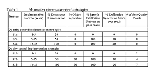
3 - Formulation of Alternative Storm Water Retrofit Strategies
The alternative
storm water quality management strategies for the Mimico watershed
were formulated by combining various mixes of appropriate RSWMP=s
in accordance with a preferred hierarchy of RSWMP=s. This hierarchy
emphasizes the use of source and drainage system controls before
downstream water quality ponds. Alternative strategies also reflect,
the experience and knowledge of the RSWMP=s, and both short and
long-term implementation constraints. Based on these principles,
alternative storm water retrofit strategies were selected as indicated
in Table 1. It is noted that runoff quality control strategies have
already included runoff volume control strategies.
Step 4 - Evaluation of Alternative Retrofit Strategies
Alternative
storm water quality management strategies were evaluated with respect
to their achievement of environmental and economic objectives. Analytical
probabilistic models (Adams and Bontje, 1983) and a multi-efficiency
model (Weatherbe, 1995) were selected for this study because the
required data and the level of accuracy are suitable for the preliminary
planning of RSWMP=s. Using derived probability theory, the analytical
probabilistic models transform long-term rainfall statistics (e.g.,
average rainfall event volume, duration, inter-event time, and average
annual number of rainfall event) into runoff statistics (e.g., average
runoff event volume and the average annual runoff volume) in an
urbanized catchment. Assuming a constant concentration of total
suspended solids, the average annual suspended solid loadings from
an urbanized catchment can be determined. The multi-efficiency model
assumes the cumulative control performance of RSWMP=s can be determined
in a manner similar to the cumulative treatment efficiency of a
series of treatment systems. The analytical and multi-efficiency
models have been coded into a RSWMP analysis spreadsheet (see Section
X.1.3) and were used to evaluate alternative storm water retrofit
strategies. The cost-effectiveness of RSWMP=s was also investigated
by comparing the marginal costs of quantity and quality controls.
In the Mimico watershed, the descending order of cost-effectiveness
is: (1) downspout disconnection; (2) water quality ponds; (3) storm
water exfiltration systems; and (4) oil/grit separators.
Step 5 - Selection of a Retrofit Strategy
The maximum
runoff volume reduction and solids loading reduction that can be
achieved in the Mimico watershed are about 14% (Strategy S3a) and
18% (Strategy S3b) and the associated costs are $7.8 million and
$10 million respectively over the next 25 years. These strategies
assume:
C All the appropriate areas for downspout disconnection will be
completed in 25 years;
C Thirty percent of appropriate areas for oil/grit separation application
will be installed in 25 years;
C All the appropriate roads which are in poor condition now will
be retrofitted with exfiltration systems in 25 years.
C Twenty percent of the appropriate roads which are in good condition
now but will be deteriorated in the next 25 years will be retrofitted
with exfiltration systems.
C Six potential water quality ponds will be constructed in the next
25 years as capital projects or redevelopment water quality controls.
If the existing swales and ditches in the watershed are assumed
to contribute to the overall runoff volume and solids loadingd reduction,
the maximum runoff volume and solids loading reduction that can
be achieved in the watershed can be increased to about 17% and 33%
respectively. Thus, maintenance of existing swales and ditches may
be an effective stormwater management measure. operational controls
such as improved street sweeping practices and increased catch basin
sump maintenance and sewer flushing are also recommended to complement
the selected strategy and improved the solids loading reduction.
Conclusions
And Recommendations
The stormwater
planning tool provides a systematic methodology for municipalities
to develop storm water quality management strategies in urbanized
watersheds. It allows municipal planners and engineers to develop
numerical control objectives and evaluate the cost-effectiveness
of alternative management strategies. Though GIS enables digital
processing of geographically-distributed data, its value for standardising
data compilation is preferred to the assembly of paper maps. The
value of GIS was clearly demonstrated in the repetition of processing
tasks such as the querying, overlaying and calculation of summary
data for each RSWMP. The use of GIS was not intended to automate
the processes of site selection and evaluation of alternatives,
but to foster the evaluation of various scenarios for retrofitting
the stormwater management system. Additional scenarios have been
suggested by the case study and will be the subject of continuing
research initiatives. With continued refinement of the tool, a higher
degree of integration of the engineering and geographic analyses
could be achieved, further streamlining the identification, evaluation
and selection functions.
Acknowledgments
This research
study was initiated and funded by Environment Canada, the Ontario
Ministry of the Environment, and the City of Toronto. Throughout
the course of the study, the Study Steering Committee members provided
excellent guidance, advice, and data to the Study Team.
References
Adams, B.J.
and Bontje, J.B. (1983). Microcomputer applications of analytical
models for urban drainage design, Proc., Emerging Computer Techniques
for Storm water and Flood Management, ASCE Specialty Conference,
101-122.
Aquafor Beech Ltd. (1994). Environmental study report Brimley Road
drainage area - water quality enhancement strategy. Report prepared
for the City of Scarborough, Ontario, Canada.
Banting,D., (1992). Data Quality Management in GIS. The Operational
Geographer 10(4) 22-26.
Banting,D., (1995). A Classification of GIS Processing Functions.
Cartouche 20 10-12.
Hipolito Jr., P. (1996). Stormwater Management: The Development
of a Database Management System for Municipal Stormwater Detention
Structures, BASc Thesis, Dept. of Civil Engineering, Ryerson Polytechnic
University.
Hydrologic Engineering Center (HEC). (1974). Manual of the Storage,
Treatment, Overflow and Runoff Model (STORM), U.S. Corps of Engineer.
Huber, W.C. and Dickson, R.E. (1988). Storm Water Management Model,
Version 4: User's Manual, U.S. EPA, Athens, Georgia.
Kauffman, G. (1987). A comparison for analytical and simulation
models for drainage system design: SUDS versus STORM, MASc Thesis,
University of Toronto, Toronto, Ontario, Canada.
Li, J. (1997). A Planning Tool for Stormwater Quality Management
in Urbanized Areas. Report prepared for Great Lakes Cleanup Fund,
Environment Canada, Burlington, Ontario.
Li, J., Tran, J., Henry, D., and Liang, W. (1997a). Development
and evaluation of the City of Etobicoke Exfiltration System, Proc.,
The Operational Water Management Conference. Copenhagen, Denmark,
407-413.
Li, J., Weatherbe,
D., Mack-Mumford, D., and D=Andrea, M. (1997b). A Screening Tool
for Stormwater Quality Management in Urbanized Areas: the City of
Scarborough Case Study. Water Quality Research Journal of Canada,
32(1), 37-52.
Li, J., Orland, R., Hogenbirk, T. (1998). Alternative drainage system.
Canadian Journal of Civil Engineering, 25(2), 26-39.
Li, J. and Banting, D. (1999) GIS as a Planning Tool for Stormwater
Management in an Urban Basin. Report prepared for Great Lakes Cleanup
Fund, Environment Canada, Burlington, Ontario.
Ministry of Environment and Energy (1994). Storm water Management
Practices Planning and Design Manual, Queen=s Printer of Ontario,
Ontario, Canada.
J.F. Sabourin and Associates Inc. (1997). Evaluation of roadside
ditches and other related stormwater management practices. Report
prepared for the Toronto and Region Conservation Authority.
Tran, J. (1994). Motel strip stormwater management plan, Report
prepared for the City of Etobicoke, Ontario.
Weatherbe, D.G (1995). Laurel Creek analysis - phosphorus , Report
prepared for the Grand River Conservation Authority, Ontario, Canada.
|